Ecoinvent geography definitions
Table of Contents
Introduction
The ecoinvent centre provide consistent and comprehensive geodata for the locations used in the ecoinvent database. This document describes how these location geometries are created and processed, and gives details on particular locations that may be confusing.
Purpose of location data in ecoinvent
Location data in ecoinvent is used to locate inventory processes in space, define and construct market and market inputs, and for various forms of regionalized life cycle inventory analysis and impact assessment.
Statement on geographical controversies
Neither the EcoSpold 2 data format, nor its authors, take any position on geographical areas of controversy. The geographical shapes presented in the EcoSpold 2 data files should not be taken as absolute definitions of country or region borders. Rather, they are approximations consistent with common understanding of these countries and regions, for use in a life cycle inventory database. If subjective judgments have to be made, we have made choices based on our understanding of what would be best for clear and understandable life cycle inventories. If you find a error or discrepancy in the base data file, please let us know by filing a bug.
Data formats
The official ecospold2 format for specifying geographies is a single XML file, with location geodata included in the KML format inside the XML file. The official geographies file is here:
However, this format is not easy to work with for most programming languages or GIS programs. The location data and metadata are also available in a number of GIS formats. Selections of the location data are also provided, as a single file containing all regions can be a bit unwieldy.
Description |
||||
|---|---|---|---|---|
All locations |
||||
Countries |
||||
All ecoinvent except for countries |
||||
UN regions |
||||
UN subregions |
||||
Electricity networks |
||||
Legacy Electricity networks |
||||
Electricity networks (USA only) |
||||
Aluminium-producing regions |
||||
Europe/Asia |
||||
Russia |
||||
Ecoinvent special |
||||
Provinces and states |
Methodology
The primary data source for the ecoinvent geodata is the Natural Earth data, and in particular the 1:10 million cultural vectors, including boundary lakes, both Admin 0 – Countries and Admin 1 – States, Provinces. In addition to Natural Earth, custom geometries were drawn for NERC regions in the United States of America which split individual states.
Processing begins by entering all province regions into a PostGIS topological database. A topology is different from a normal geometry because it tries to store only one copy of each face edge and node, and a state or province would be defined by which common edges it bordered. For example, the boundary between France and Germany would be stored only once, and the topology of both France and Germany would reference that border. Topology is a rather complex subject which is not explained in detail here; interested readers should go through this presentation by Sandro Santilli. The use of topologies give several nice advantages:
Consistency: Each border is only defined once. Modifications to border edges apply to all affected regions automatically.
Integrity: All regions are automatically valid.
Explicit relationships: It is fast and simple to determine spatial relationships among regions by comparing their topological faces. There is no potential for floating-point errors, as no geometry math is needed.
You can download the current set of topological faces used in Ecoinvent here.
After state/province-level data is imported, country data is imported. Country borders are automatically snapped to province borders by the database. A series of data cleaning steps is then applied. Specifically, the following is done:
Provinces with self-intersecting borders are fixed using ST_MakeValid. We don’t think this is a problem in the 2023 release of Natural Earth, but is kept for safety.
Countries whose ISO names are longer than normal, or whose names who result in unexpected sort order, are changed (
update_names.sql).Republic of Serbiais changed toSerbiaSvalbard and Jan MayenandBouvet Islandgeometries are removed fromNorway; they have separate ISO codesCyprus No Mans Areageometry is removed fromCyprus;Cyprus No Mans Areais a separate locationTokelaugeometry is removed fromNew Zealand;Tokelauhas a separate ISO codeBaikonur cosmodroneis reassigned fromRussiatoKazakhstanNetherlandsis redefined to not include its Caribbean islands, which have their own ISO codeFranceis redefined to not include territories which have their own ISO codes (See France)Kosovois given the provisional ISO codeXK.The Mandarin names of the Chinese provinces
HeilongjiangandQinghaiare corrected.Democratic Republic of the Congois changed toCongo, Democratic Republic of theRepublic of Congois changed toCongoFederated States of Micronesiais changed toMicronesia, Federated States ofUnited Republic of Tanzaniais changed toTanzania
In addition, the United States of America is split into the regional transmission grids, whose borders do not follow state borders.
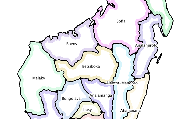
The basic topological units in the database are usually state/province-level regions, as in this visualization of Madagascar:
However, in some regions states are broken up, as in this visualization of the combination of NERC regions and state boundaries in the United States of America:

Ecoinvent regions are defined constructively, i.e. they are built up by adding together their smallest constituent units. Intersection or difference functions are not used, as they can lead to floating-point errors and small geometrical artifacts.
After a consistent topology is constructed, the regions used in ecoinvent are extracted. For example, ecoinvent provides Australian states, so these are added individually; however, state-level data in most other countries are not used, so only the country borders are extracted. The final ecoinvent topology of the world looks like this:

The input data and scripts to process, combine, and export all location data, as well as this manual, are open source and freely available for download.
List of locations in ecoinvent
Countries
259 entities listed in ISO 3166-1:
Afghanistan |
Akrotiri Sovereign Base Area |
Aland |
Albania |
Algeria |
American Samoa |
Andorra |
Angola |
Anguilla |
Antarctica |
Antigua and Barbuda |
Argentina |
Armenia |
Aruba |
Ashmore and Cartier Islands |
Australia |
Austria |
Azerbaijan |
Bahrain |
Bajo Nuevo Bank (Petrel Is.) |
Bangladesh |
Barbados |
Belarus |
Belgium |
Belize |
Benin |
Bermuda |
Bhutan |
Bolivia |
Bonaire, Saint Eustatius and Saba |
Bosnia and Herzegovina |
Botswana |
Bouvet Island |
Brazil |
British Indian Ocean Territory |
British Virgin Islands |
Brunei |
Bulgaria |
Burkina Faso |
Burundi |
Cambodia |
Cameroon |
Canada |
Cape Verde |
Cayman Islands |
Central African Republic |
Chad |
Chile |
China |
Clipperton Island |
Colombia |
Comoros |
Congo |
Congo, Democratic Republic of the |
Cook Islands |
Costa Rica |
Croatia |
Cuba |
Curaçao |
Cyprus |
Cyprus No Mans Area |
Czechia |
Denmark |
Dhekelia Sovereign Base Area |
Djibouti |
Dominica |
Dominican Republic |
East Timor |
Ecuador |
Egypt |
El Salvador |
Equatorial Guinea |
Eritrea |
Estonia |
Ethiopia |
Falkland Islands |
Faroe Islands |
Fiji |
Finland |
France |
French Guiana |
French Polynesia |
French Southern and Antarctic Lands |
Gabon |
Gambia |
Georgia |
Germany |
Ghana |
Gibraltar |
Greece |
Greenland |
Grenada |
Guadeloupe |
Guam |
Guatemala |
Guernsey |
Guinea |
Guinea Bissau |
Guyana |
Haiti |
Heard Island and McDonald Islands |
Honduras |
Hong Kong S.A.R. |
Hungary |
Iceland |
India |
Indonesia |
Iran |
Iraq |
Ireland |
Isle of Man |
Israel |
Italy |
Ivory Coast |
Jamaica |
Japan |
Jersey |
Jordan |
Kazakhstan |
Kenya |
Kiribati |
Kuwait |
Kyrgyzstan |
Laos |
Latvia |
Lebanon |
Lesotho |
Liberia |
Libya |
Liechtenstein |
Lithuania |
Luxembourg |
Macao S.A.R |
North Macedonia |
Madagascar |
Malawi |
Malaysia |
Maldives |
Mali |
Malta |
Marshall Islands |
Martinique |
Mauritania |
Mauritius |
Mayotte |
Mexico |
Micronesia, Federated States of |
Moldova |
Monaco |
Mongolia |
Montenegro |
Montserrat |
Morocco |
Mozambique |
Myanmar |
Namibia |
Nauru |
Nepal |
Netherlands |
New Caledonia |
New Zealand |
Nicaragua |
Niger |
Nigeria |
Niue |
Norfolk Island |
North Korea |
Northern Cyprus |
Northern Mariana Islands |
Norway |
Oman |
Pakistan |
Palau |
Palestine |
Panama |
Papua New Guinea |
Paraguay |
Peru |
Philippines |
Pitcairn Islands |
Poland |
Portugal |
Puerto Rico |
Qatar |
Romania |
Russia |
Rwanda |
Réunion |
Saint Barthelemy |
Saint Helena |
Saint Kitts and Nevis |
Saint Lucia |
Saint Martin |
Saint Pierre and Miquelon |
Saint Vincent and the Grenadines |
Samoa |
San Marino |
Sao Tome and Principe |
Saudi Arabia |
Scarborough Reef |
Senegal |
Serbia |
Serranilla Bank |
Seychelles |
Siachen Glacier |
Sierra Leone |
Singapore |
Sint Maarten |
Slovakia |
Slovenia |
Solomon Islands |
Somalia |
South Africa |
South Georgia and South Sandwich Islands |
South Korea |
South Sudan |
Spain |
Spratly Islands |
Sri Lanka |
Sudan |
Suriname |
Svalbard and Jan Mayen |
Eswatini |
Sweden |
Switzerland |
Syria |
Taiwan |
Tajikistan |
Tanzania |
Thailand |
The Bahamas |
Togo |
Tokelau |
Tonga |
Trinidad and Tobago |
Tunisia |
Türkiye |
Turkmenistan |
Turks and Caicos Islands |
Tuvalu |
US Naval Base Guantanamo Bay |
Uganda |
Ukraine |
United Arab Emirates |
United Kingdom |
United States Minor Outlying Islands |
United States Virgin Islands |
United States of America |
Uruguay |
Uzbekistan |
Vanuatu |
Vatican |
Venezuela |
Vietnam |
Wallis and Futuna |
Western Sahara |
Yemen |
Zambia |
Zimbabwe |
De facto independent countries
The country of Kosovo is included, although it is not yet completely internationally recognized.
Somaliland (Wikipedia) is included as a separate location. Somalia does not include Somaliland.
Disputed areas and indepedent military bases
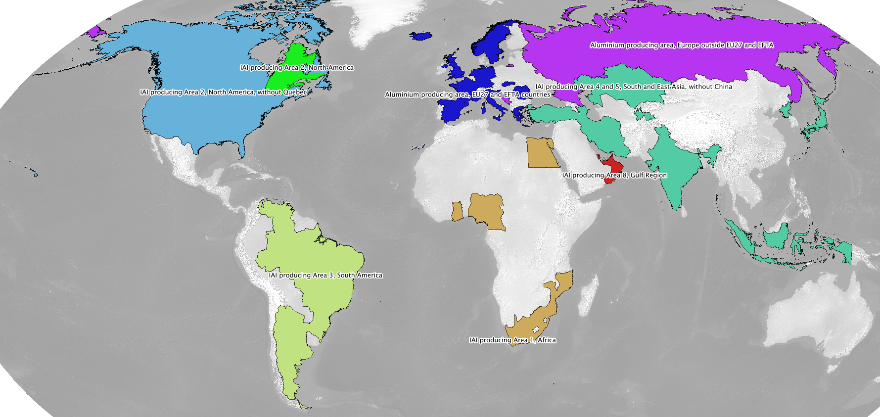
International Aluminium Institute regions
The International Aluminium Institute regions are roughly followed, although with some ecoinvent-specific modifications.
Note
IAI producing Area 1, Africa
IAI producing Area 2, North America
IAI producing Area 2, North America, without Quebec
IAI producing Area 3, South America
IAI producing Area 4 and 5, South and East Asia, without China
Aluminium producing area, EU27 and EFTA countries
Aluminium producing area, Europe outside EU27 and EFTA
IAI producing Area 8, Gulf Region
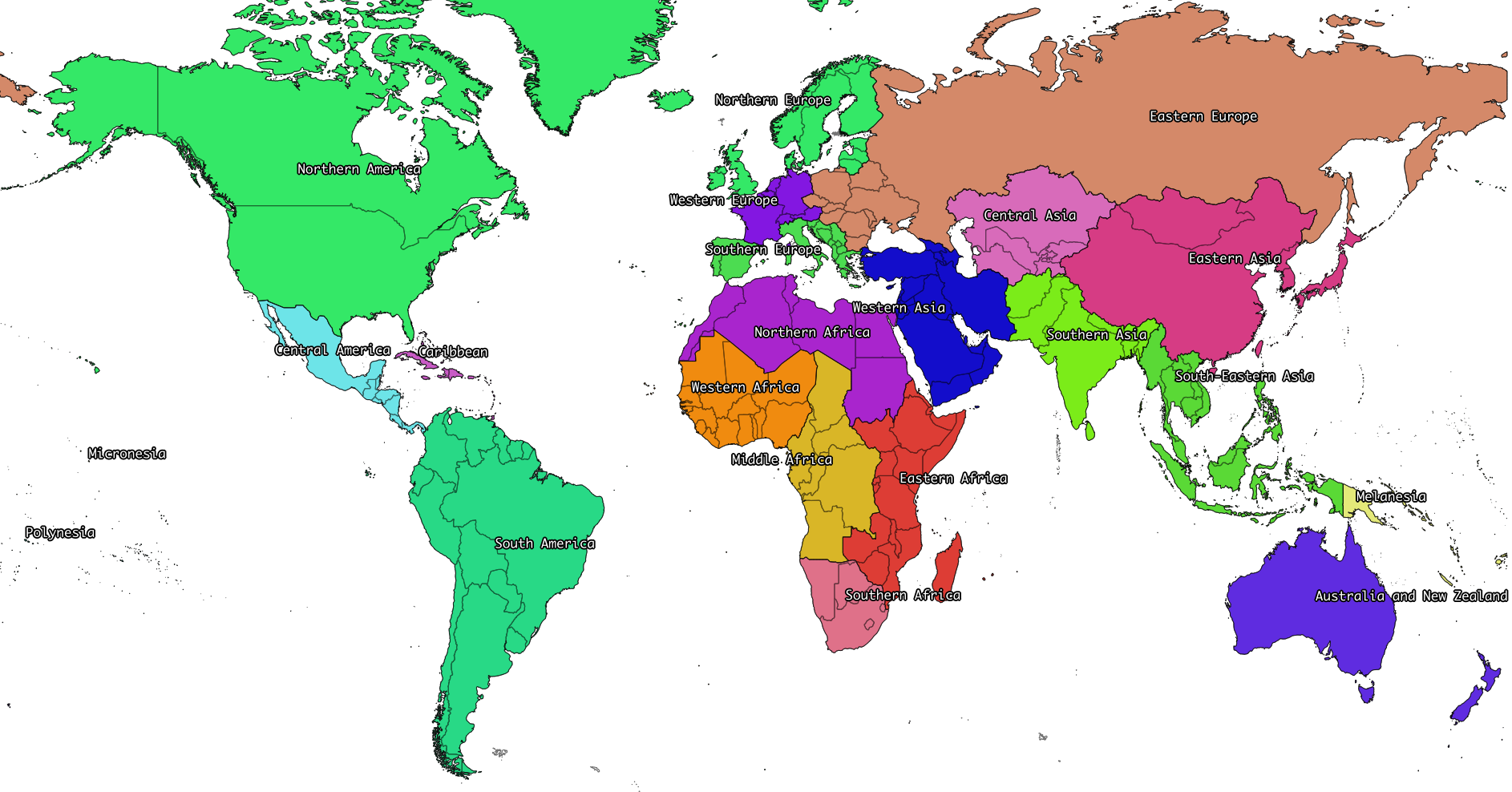
UN regions and subregions
All UN macro geographical regions and subregions are included.
Note
See also graphical descriptions of UN regions and UN subregions.
UN regions
Africa
Americas
Asia, UN Region
Europe, UN Region
Oceania
UN subregions
Australia and New Zealand
Caribbean
Central America
Central Asia
Eastern Africa
Eastern Asia
Eastern Europe
Latin America and the Caribbean
Melanesia
Micronesia
Middle Africa
Northern Africa
Northern America
Northern Europe
Polynesia
South America
South-Eastern Asia
Southern Africa
Southern Asia
Southern Europe
Western Africa
Western Asia
Western Europe
Electricity networks
North America
Note
See also specific comments on North American networks and USA-only subnetworks.
Alaska Systems Coordinating Council
Florida Reliability Coordinating Council
HICC (Hawaii)
Midwest Reliability Organization
Midwest Reliability Organization, US part only
Northeast Power Coordinating Council
Northeast Power Coordinating Council, US part only
ReliabilityFirst Corporation
SERC Reliability Corporation
Southwest Power Pool
Texas Regional Entity
Western Electricity Coordinating Council
Western Electricity Coordinating Council, US part only
Europe
Note
See also specific comments on European Legacy networks.
Baltic System Operator
Central European Power Association
European Network of Transmission Systems Operators for Electricity
Nordic Countries Power Association
Union for the Co-ordination of Transmission of Electricity
Ecoinvent special locations
“Cut-out” locations
Due to the way markets are linked, it is sometimes necessary to create regions without specific states or countries. The following are current included:
Asia without China
Canada without Alberta
Canada without Alberta and Quebec
Canada without Quebec
China without Inner Mongol
Europe without Austria
Europe without Austria, Belgium, France, Germany, Italy, Liechtenstein, Monaco, San Marino, Switzerland, and the Vatican
Europe without Germany and Switzerland
Europe without Germany, the Netherlands, and Norway
Europe without Germany, the Netherlands, Norway, and Russia
Europe without NORDEL (NCPA)
Europe without Switzerland
Europe without Switzerland and Austria
Europe without Switzerland and France
Europe, without Russia
Europe, without Russia and Türkiye
UCTE without France
UCTE without Germany
UCTE without Germany and France
Trading blocks
Commonwealth of Independent States
North American Free Trade Agreement
Miscellaneous
Canary Islands (Spain also includes the Canary Islands)
France, including overseas territories (See France)
Middle East (Iran, Iraq, Kuwait, Saudi Arabia, and the United Arab Emirates)
Québec, Hydro-Québec distribution network
Serbia and Montenegro (Legacy location; Both
SerbiaandMontenegroare included as countries)
Australian states and territories

In addition to the country Australia, the Australian states and territories are also provided.
States and internal territories:
Australian Capital Territory
New South Wales
Northern Territory
Queensland
South Australia
Tasmania
Victoria
Western Australia
Jervis Bay Territory
External territories:
Ashmore and Cartier Islands
Christmas Island
Cocos (Keeling) Islands
Coral Sea Islands
Heard Island and McDonald Islands
Norfolk Island
Australia includes all states and internal territories. Australia, including overseas territories includes all external territories as well as states and internal territories.
The geography Australia, Indian Ocean Territories, consisting of Christmas Island and Cocos (Keeling) Islands is provided, but its use is not recommended.
Brazilian states
In addition to the country Brazil, the Brazilian states are also provided.
Acre
Alagoas
Amapá
Amazonas
Bahia
Ceará
Distrito Federal
Espírito Santo
Goiás
Maranhão
Mato Grosso
Mato Grosso do Sul
Minas Gerais
Paraná
Paraíba
Pará
Pernambuco
Piauí
Rio de Janeiro
Rio Grande do Norte
Rio Grande do Sul
Rondônia
Roraima
Santa Catarina
Sergipe
São Paulo
Tocantins
Canadian provinces
In addition to the country Canada, the Canadian provinces are also provided.
Alberta
British Columbia
Manitoba
New Brunswick
Newfoundland and Labrador
Northwest Territories
Nova Scotia
Nunavut
Ontario
Prince Edward Island
Québec
Saskatchewan
Yukon
Chinese provinces
In addition to the country China, the Chinese provinces are also provided.
Anhui (安徽)
Beijing (北京)
Chongqing (重庆)
Fujian (福建)
Gansu (甘肃)
Guangdong (广东)
Guangxi (广西壮族自治区)
Guizhou (贵州)
Hainan (海南)
Hebei (河北)
Heilongjiang (黑龙江省)
Henan (河南)
Hubei (湖北)
Hunan (湖南)
Inner Mongol (内蒙古自治区)
Jiangsu (江苏)
Jiangxi (江西)
Jilin (吉林)
Liaoning (辽宁)
Ningxia (宁夏回族自治区)
Qinghai (青海)
Shaanxi (陕西)
Shandong (山东)
Shanghai (上海)
Shanxi (山西)
Sichuan (四川)
Tianjin (天津)
Xinjiang (新疆维吾尔自治区)
Xizang (西藏自治区)
Yunnan (云南)
Zhejiang (浙江)
Indian states and territories
In addition to the country India, the Indian states and union territories are also provided.
Andaman and Nicobar
Andhra Pradesh
Arunachal Pradesh
Assam
Bihar
Chandigarh
Chhattisgarh
Dadra and Nagar Haveli and Daman and Diu
Delhi
Goa
Gujarat
Haryana
Himachal Pradesh
Jammu and Kashmir
Jharkhand
Karnataka
Kerala
Lakshadweep
Madhya Pradesh
Maharashtra
Manipur
Meghalaya
Mizoram
Nagaland
Odisha
Puducherry
Punjab
Rajasthan
Sikkim
Tamil Nadu
Telangana
Tripura
Uttar Pradesh
Uttarakhand
West Bengal
United States of America states
In addition to the country United States of America, the American states and the District of Columbia are also provided.
Alabama
Alaska
Arizona
Arkansas
California
Colorado
Connecticut
Delaware
District of Columbia
Florida
Georgia
Hawaii
Idaho
Illinois
Indiana
Iowa
Kansas
Kentucky
Louisiana
Maine
Maryland
Massachusetts
Michigan
Minnesota
Mississippi
Missouri
Montana
Nebraska
Nevada
New Hampshire
New Jersey
New Mexico
New York
North Carolina
North Dakota
Ohio
Oklahoma
Oregon
Pennsylvania
Rhode Island
South Carolina
South Dakota
Tennessee
Texas
Utah
Vermont
Virginia
Washington
West Virginia
Wisconsin
Wyoming
Changelog
Version 2.5 (Ecoinvent 3.10)
Updated to Natural Earth data version 5.1.1.
Completely rewritten pipeline and scripts using only the province-level Natural Earth data. By not needing to reconcile province and country borders, processing time is reduced from hours to minutes.
Indian states of
Dadra and Nagar HaveliandDaman and Diuwere merged in 2020 toDadra and Nagar Haveli and Daman and Diu.Indian state of
Orissawas renamed toOdishain 2011 - we include this change already in 2023.Changed
TurkeytoTürkiye, andEurope, without Russia and TurkeytoEurope, without Russia and Türkiye.Adapted NERC regions as US-SPP and US-FRCC were both dissolved. See the source repo for more information. The regions
Southwest Power PoolandFlorida Reliability Coordinating Councilwere removed.Add regional Chinese electricity grids.
Restored
Brazil, South-eastern and Mid-western grid.The modelling and names for Australia were revamped. See Australian states and territories.
Version 2.4 (ecoinvent 3.7)
Added Europe without Switzerland and Austria, Europe without Austria, China without Inner Mongol.
Added 50 states of the United States of America, as well as the District of Columbia.
The name of Al producing Area 6A&B, West, East, and Central Europe (which was in any case an outdated location, and not used in ecoinvent) was changed to IAI Area, West Europe, for consistency with the ecoinvent master data.
Version 2.3 (ecoinvent 3.6)
Split Brazil, South-eastern and Mid-western grid into Brazil, South-eastern grid and Brazil, Mid-western grid.
Fixed the short names of the IAI regions to make them consistent with ecoinvent master data:
IAI Area, Europe outside EU & EFTAis nowIAI Area, Russia & RER w/o EU27 & EFTAIAI Area 1, Africais nowIAI Area, AfricaIAI Area 2, North Americais nowIAI Area, North AmericaIAI Area 2, without Quebecis nowIAI Area, North America, without QuebecIAI Area 3, South Americais nowIAI Area, South AmericaIAI Area 4&5, without Chinais nowIAI Area, Asia, without China and GCCIAI Area 6, Europeis nowIAI Area, West EuropeIAI Area 8, Gulfis nowIAI Area, Gulf Cooperation Council
Added Europe without Russia and North America without Quebec.
Updated country name of Eswatini and North Macedonia.
Version 2.2 (ecoinvent 3.4)
The country formerly known as the Czech Republic is now Czechia.
Added Europe without Germany, the Netherlands, and Russia and Europe without Switzerland and France.
Changed the code of Canada without Quebec from ROC to Canada without Quebec.
Improved consistency in codes and names of provinces to include their countries:
Ashmore and Cartier Islandsis nowAustralia, Ashmore and Cartier Islands(codeAUS-AC)Indian Ocean Territoriesis nowAustralia, Indian Ocean Territories(codeAUS-IOT)China Southern Power Gridcode is nowCN-CSGState Grid Corporation of Chinacode is nowCN-SGCCAlaska Systems Coordinating Councilcode is nowUS-ASCCFlorida Reliability Coordinating Councilcode is nowUS-FRCCHICCcode is nowUS-HICCMidwest Reliability Organization, US part onlycode is nowUS-MRONortheast Power Coordinating Council, US part onlycode is nowUS-NPCCReliabilityFirst Corporationcode is nowUS-RFCSERC Reliability Corporationcode is nowUS-SERCSouthwest Power Poolcode is nowUS-SPPTexas Regional Entitycode is nowUS-TREWestern Electricity Coordinating Council, US part onlycode is nowUS-WECC
Changed several country names for consistency with ecoinvent:
Brunei Darussalamis nowBruneiDemocratic Republic of the Congois nowCongo, Democratic Republic of theFalkland Islands (Malvinas)is nowFalkland IslandsHong Kongis nowHong Kong S.A.R.Macauis nowMacao S.A.RMicronesia (Federated States of)is nowMicronesia, Federated States ofPitcairnis nowPitcairn IslandsRepublic of Congois nowCongoUnited Republic of Tanzaniais nowTanzaniaÅland Islandsis nowAland
Fixed several bugs:
The new names of some regions in version 2.0 were not properly updated
All areas of Cyprus are now included in Asia
Saskatchewan is now included in Canada
Version 2.1 (ecoinvent 3.3)
The following electricity grids were added:
Brazil, North-eastern grid
Brazil, Northern grid
Brazil, South-eastern and Mid-western grid
Brazil, Southern grid
India, Islands
India, North-eastern grid
India, Northern grid
India, Southern grid
India, Western grid
Additionally, all states and union territories in both India and Brazil were added.
The composite geometries Europe without Germany, the Netherlands, Norway, and Russia and Europe without Switzerland and France were also added.
Version 2.0 (ecoinvent 3.2)
No locations used in ecoinvent 3.01 or 3.1 have been removed, and no location shortnames or UUIDs have been changed. Ecoinvent geography definitions version 2.0 should therefore be backwards-compatible with version 1.0.
The following locations were added:
Aluminium producing area, EU27 and EFTA countries
Aluminium producing area, Europe outside EU27 and EFTA
Caribbean (UN subregion)
Coral Sea Islands (administrative unit of Australia)
Indian Ocean Territories (administrative unit of Australia)
Russia (Asia)
Russia (Europe)
The location Al producing Area 6A&B, West, East, and Central Europe, which was not used in ecoinvent 3.01 or 3.1, has been split into Aluminium producing area, EU27 and EFTA countries and Aluminium producing area, Europe outside EU27 and EFTA.
Note
Sovereign military bases are necessary in version 2 for a consistent world topology.
The following names were changed, mostly due to changes in the source data, or to choose the common instead of formal names:
New name |
Old name |
|---|---|
IAI producing Area 8, Gulf Region |
IAI producing Area 8, Gulf-Aluminium Council/Gulf Region |
Aland |
Åland Islands |
Bolivia |
Bolivia, Plurinational State of |
Bonaire, Saint Eustatius and Saba |
Bonaire, Sint Eustatius, and Saba |
British Virgin Islands |
Virgin Islands, British |
Brunei |
Brunei Darussalam |
East Timor |
Timor-Leste |
Falkland Islands |
Falkland Islands (Malvinas) |
French Southern and Antarctic Lands |
French Southern Territories |
Guinea Bissau |
Guinea-Bissau |
Hong Kong S.A.R. |
Hong Kong |
Iran |
Iran (Islamic Republic of) |
Ivory Coast |
Cote d’Ivoire |
Laos |
Lao People’s Democratic Republic |
Macao S.A.R |
Macau |
North Macedonia |
Macedonia, the Former Yugoslav Republic of |
Moldova |
Moldova, Republic of |
North Korea |
Korea, Democratic People’s Republic of |
Palestine |
Palestinian Territory, Occupied |
Pitcairn Islands |
Pitcairn |
Réunion |
Reunion |
Russia |
Russian Federation |
South Georgia and South Sandwich Islands |
South Georgia and the South Sandwich Islands |
South Korea |
Korea, Republic of |
Southern Asia |
South Asia |
Syria |
Syrian Arab Republic |
Taiwan |
Taiwan, Province of China |
Tanzania |
Tanzania, United Republic Of |
The Bahamas |
Bahamas |
United States of America |
United States |
United States Virgin Islands |
Virgin Islands, U.S. |
Vatican |
Holy See (Vatican City State) |
Vietnam |
Viet Nam |
Yukon |
Yukon Territory |
The following unused locations have been removed:
Location |
Comment |
|---|---|
Central and Eastern Europe |
|
Christmas Island |
Now included in Indian Ocean Territories |
Cocos (Keeling) Islands |
Now included in Indian Ocean Territories |
Spain, including overseas territories |
Version 1.0 (ecoinvent 3.01 & 3.1)
Initial development. Removal of locations no longer used in the ecoinvent database.
Notes on specific geometries
Some images are large, and can be opened in a separate tab to be seen in full detail.
Global and Rest of the World
The Global dataset does not have a KML description.
The Rest of the world dataset is a dynamic concept that exists in the situation when both a global dataset and one or more non-global datasets are available for the same activity, time period, and macro-economic scenario. The definitions is specific to each activity and depends on what defined geographies are available for the specific activity name. It is defined as the difference between the global reference dataset and the datasets with defined geographies. The “rest of world” dataset does not have a set KML description.
UN Regions and subregions
UN regions and subregions follow the UN macro geographical regions definitions.
UN regions
Note
Taiwan is included in the UN region Asia and the UN subregion Eastern Asia, even though it is not officially listed in the UN definitions.

UN subregions
The UN subregion Latin America and the Caribbean, not shown, includes the Caribbean, and Central and South America.
Europe and Asia
The following locations are given:
Europe(short nameRER)Asia(short nameRAS)Europe, UN Region(short nameUN-EUROPE)Asia, UN Region(short nameUN-ASIA)
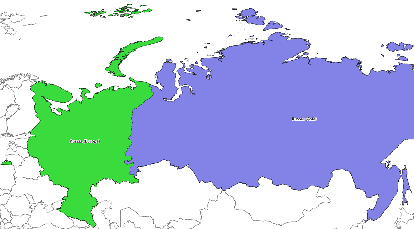
We differentiate between the UN definitions of Europe and Asia (which are constrained to including or excluding entire countries), and the common understanding of the border between Europe and Asia. There is no clear line dividing Europe and Asia. The UN regions are defined following the UN macro geographical regions. Russia is split by federal subjects, with the following federal subjects in Europe:
Adygey |
Arkhangel’sk |
Astrakhan’ |
Bashkortostan |
Belgorod |
Bryansk |
Chechnya |
Chuvash |
City of St. Petersburg |
Dagestan |
Ingush |
Ivanovo |
Kabardin-Balkar |
Kaliningrad |
Kalmyk |
Kaluga |
Karachay-Cherkess |
Karelia |
Kirov |
Komi |
Kostroma |
Krasnodar |
Kursk |
Leningrad |
Lipetsk |
Mariy-El |
Mordovia |
Moskovsskaya |
Moskva |
Murmansk |
Nenets |
Nizhegorod |
North Ossetia |
Novgorod |
Orel |
Orenburg |
Penza |
Perm’ |
Pskov |
Rostov |
Ryazan’ |
Samara |
Saratov |
Smolensk |
Stavropol’ |
Tambov |
Tatarstan |
Tula |
Tver’ |
Udmurt |
Ul’yanovsk |
Vladimir |
Volgograd |
Vologda |
Voronezh |
Yaroslavl’ |
The following Russian federal subjects are in Asia:
Altay |
Amur |
Buryat |
Chelyabinsk |
Chita |
Chukchi Autonomous Okrug |
Gorno-Altay |
Irkutsk |
Kamchatka |
Kemerovo |
Khabarovsk |
Khakass |
Khanty-Mansiy |
Krasnoyarsk |
Kurgan |
Maga Buryatdan |
Novosibirsk |
Omsk |
Primor’ye |
Sakha (Yakutia) |
Sakhalin |
Sverdlovsk |
Tomsk |
Tuva |
Tyumen’ |
Yamal-Nenets |
Yevrey |
Note
The definition of Europe and Asia have changed in version 2.0, to match Russian federal subject borders. In version 1.0, Europe also included parts of Kazakhstan, Azerbaijan, Georgia, and Türkiye - these countries are now completely inside Asia.
Note
Both Europe and Europe, UN Region include all of Spain, including the Canary Islands and a few small exclaves in Africa.

In addition to the country Russia, the regions Russia (Asia) and Russia (Europe) are given, following the federal subject boundaries given above.
Aluminium-producing regions
Aluminium is not produced in every country in the world, and the following producing regions are given:
IAI producing Area 1, Africa
IAI producing Area 2, North America
IAI producing Area 2, North America, without Quebec
IAI producing Area 3, South America
IAI producing Area 4 and 5, South and East Asia, without China
Aluminium producing area, EU27 and EFTA countries
Aluminium producing area, Europe outside EU27 and EFTA
IAI producing Area 8, Gulf Region
Note that there is an overlap between IAI producing Area 2, North America and IAI producing Area 2, North America, without Quebec.
Electricity networks
Sub-national electricity grids are provided for China, Brazil, North America, and India.
North American networks
In the United States and Canada, the boundaries between NERC regions is made up of state/province boundaries and hand-drawn boundaries traced from NERC maps.

USA-only subnetworks
NERC regions which cross the Canadian border have also been split into USA-only networks for market reasons.

India
India has been split into five electricity grids. The location India, Islands contains both Andaman and Nicobar, and Lakshadweep.

Brazil
Brazil has been split into four electricity grids.

China
China has been split into six electricity grids.

Legacy networks
In addition to these current networks, the following legacy European networks are provided:
Nordic Countries Power Association
Union for the Co-ordination of Electricity
Baltic System Operator

Central European Power Association

Norway
Bouvet Island and Svalbard and Jan Mayen are distinct locations with ISO 3166-1 codes and are not included in Norway.
France
France is what is commonly called metropolitan France. It does not include the following locations which all have ISO 3166-1 codes:
French Guiana
French Polynesia
French Southern and Antarctic Lands
Guadeloupe
Martinique
Mayotte
New Caledonia
Réunion
Saint Barthélemy
Saint Martin
Saint Pierre and Miquelon
Wallis and Futuna
In addition, France does not include the uninhabited Clipperton Island, which is given as a separate location.
The location France, including overseas territories includes metropolitan France, as well as French Guiana, Guadeloupe, Martinique, Mayotte, and Réunion.
Spain
Spain includes the Canary Islands, Ceuta, Melilla, and the Plazas de soberanía.
Micronesia
The country is called Micronesia, Federated States of. The UN subregion is called Micronesia.
Cyprus
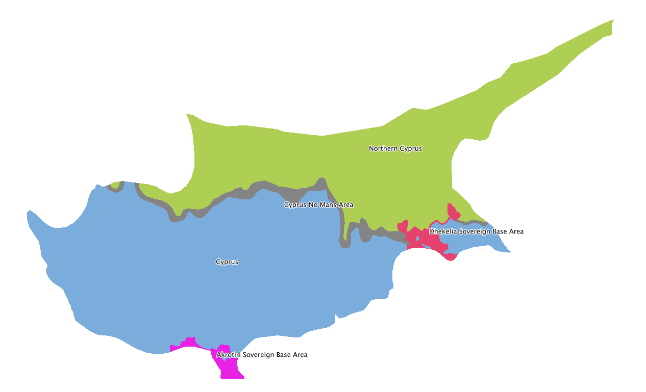
Due to ongoing territorial disputes, the island of Cyprus is split into the following:
United States of America
The location United States of America includes the 50 states and Washington D.C. The following are given as separate locations:
American Samoa
Guam
Northern Mariana Islands
Puerto Rico
United States Minor Outlying Islands
United States Virgin Islands